|
|
|
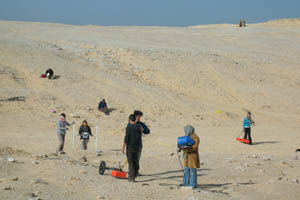
My task was to assist with laying out the
grids and locating these so that they could be related
to each other as well as to existing aerial photographs
and plans of the ancient city:
|
|
|
|
|
 |
|
 |
|
|
|
|
|
|
|
|
|
|
To assist in the geophysical
survey of the Central City, the Southern Cemetery, and
the Stone Village. |
|
|
|
- January 2011 - October/November 2012 (for survey work at the Great Aten Temple) |
|
|
|
Project director Barry Kemp,
archaeological geophysicist Jason Herrmann (2011), and
students of the Tell el-Amarna Geophysical Field School. |
|
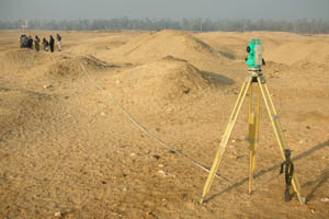
| Results: | A large number of geophysical maps created with different techniques (gradiometry, conductivity and ground penetrating radar) combined with low-level aerial imagery from a helium balloon. | |
| Approximate position and date of the site: | The ancient Egyptian city Akhetaton (modern
Tell el-Amarna, or simply Amarna) was founded around
1347 BCE by Pharaoh Akhenaton as part of his efforts to
install new religious practices in Egypt and reduce the
power of the priests. To symbolize his break with the
past Akhenaton changed his name from Amenhotep IV and
moved the capital of Egypt to Akhetaton. Amarna
is located on the east bank of the Nile in Minya
Province, about half-way between Cairo and Luxor
(ancient Memphis
and Thebes).
Apart from palaces for the Pharoah and administrative
buildings, the city also had several temples dedicated
to the worship of the Sun (Atonism). Shortly after the
death of Akhenaton, around 1332 BCE, the capital was
moved back to Memphis
and Thebes
(modern Cairo and Luxor) and Amarna was abandoned.
Following that, most of the monuments, inscriptions and
other remains of the period were destroyed in an effort
to erase the memory of Akhenaton from history. |
|
| Short description of the site: | Amarna is located just east
of the Nile, on a flat stretch of desert, about 5x10 km.
in size, between the Nile Valley and the escarpment
marking the edge of the Eastern Desert. The limits of
the ancient city is marked by
numerous boundary stelae. The city comprises the North City, the Central City and the
South Suburbs; further east are the North Tombs, the
Royal Wadi, the Workmen's Village, the Stone Village and
the South Tombs. As the city was mostly built of
mudbrick and purposefully destroyed after the death of
Akhenaton its remains are mostly limited to its
foundation levels. Amarna is unique as it provides a
snapshot of Ancient Egypt, the remains of which
furthermore are mostly tombs and temples with only very
few settlements available for research. The most important finds from Amarna include
a painted limestone bust of Queen Nefertiti (now in
Berlin) and the Amarna Letters (in cuneiform). |
|
| Additional remarks: | Unfortunately our stay in
Egypt was cut
short by the political events of 2011 in the
region. My participation in this project would not have
been possible without the support of the Amarna Trust,
the Center for Advanced
Spatial Technologies, the Cotsen Institute of
Archaeology, and many individuals. The field school in October/November 2012 concentrated on cleaning and surveying the gypsum foundations of the Great Aten Temple, excavated by John Pendlebury in the 1920s. |
|
| HOME |
|
 |