|
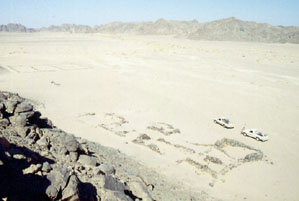
An overview of Bab al-Mukhenig looking south, with
the road station in the foreground and part of the animal lines at the
left of the picture:
|
|
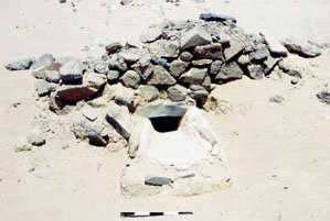
A water channel was found to be passing under the
wall of the main building at Bab al-Mukhenig:
|
|
|
|
|
|
|
|
|
|
|
|
|
|
|
|
Objective of visit:
|
|
To draw a measured plan of the site and study the surface
remains (including the ceramic finds). |
|
Date of visit:
|
|
- July 1996 |
|
Fellow visitors:
|
|
Prof.Dr. Steve Sidebotham (University of Delaware) and
Saleh Ali (our bedouin guide). |
| Results: |
|
A survey was performed using the Global Positioning System,
a theodolite and steel tape measures. Off-site assistance was given by
pottery expert Dr. Roberta Tomber (Museum of London). No excavations took
place. A full publication of this site is pending. |
| Approximate position and date
of the site: |
|
Bab al-Mukhenig is in the northern part of the Egyptian
Eastern desert, north of the Qena-Safaga asphalt road, west of the Mons
Claudianus and Mons Porphyrites area. Surface pottery dated to the Roman
period (ca. 30 - 600 AD). |
| Short description of the site: |
|
Bab al-Mukhenig was a stop on the ancient road from the
stone quarries in the Mons Claudianus and Mons Porphyrites area to the
Nile. Here caravans could find water, food and shelter for the night. |
| Additional remarks: |
|
Judging by the size as well as the lay-out of the remaining
buildings, including the animal lines, Bab al-Mukhenig was not af major
importance to the ancient traffic. Our work was sponsored by the University
of Delaware and private donors. |
| HOME |
|
|
 |
|
|