|
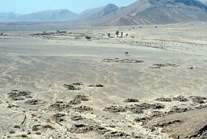
The settlement at Nakheil looking south. In the distance
the palm trees, after which the site is named, can be seen close to the
remains of a heavily disturbed Roman hydreuma:
|
|
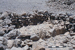
A close-up of one of the structures in the settlement
at Nakheil showing their rather simple lay-out and construction:
|
|
|
|
|
|
|
|
|
|
|
|
|
|
|
|
Objective of visit:
|
|
To draw a measured plan of the site and study the surface
remains (including the ceramic finds). |
|
Date of visit:
|
|
- June 1999 |
|
Fellow visitors:
|
|
Prof.Dr. Steve Sidebotham (University of Delaware). |
| Results: |
|
A survey was performed using the Global Positioning System,
a theodolite and steel tape measures. Off-site assistance was given by
pottery expert Dr. Roberta Tomber (Museum of London). No excavations took
place. Due to lack of time our work on site was left unfinished. |
| Approximate position and date
of the site: |
|
Nakheil is in the southern part of the Egyptian Eastern
desert, just north of the Quft-Quseir asphalt road and close to the Red
Sea coast. Surface pottery dated to the Ptolemaic period (ca. 330
- 30 BC). |
| Short description of the site: |
|
The settlement at Nakheil served some kind of mining
operation. The Ptolemaic site is in between a neo-lithic settlement to
the north, and a Roman hydreuma to the south. The site comprises
a large number of simple huts at the southern base of the foothills. |
| Additional remarks: |
|
The settlement at Nakheil is rather well preserved whereas
the Roman hydreuma is heavily damaged. Due to lack of time the survey
of Nakheil was left unfinished. Our work was sponsored by the University
of Delaware and private donors. |
| HOME |
|
|
 |
|
|