|
|
|
It may well have been a shrine: |
|
|
|
|
 |
|
 |
|
|
|
|
|
|
|
|
|
|
|
To draw a measured plan of the site and study the surface remains (including the ceramic finds). |
|
|
- July 1996
- August 1997 |
|
|
|
Prof.Dr. Steve Sidebotham (University of Delaware) and Saleh Ali (our bedouin guide). | |
| Results: | A survey was performed using the Global Positioning System, a theodolite and steel tape measures. Off-site assistance was given by pottery expert Dr. Roberta Tomber (Museum of London). No excavations took place. A full publication of this site is pending. | |
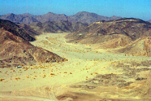
| Approximate position and date of the site: | Bir Sirbakis is in the central part of the Egyptian Eastern desert, just south of the Qena-Safaga asphalt road and just west of Bukhelug. Most surface pottery dated to the Ptolemaic period (ca. 330 - 30 BC) and later. | |
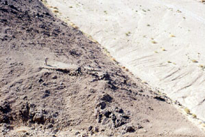
| Short description of the site: | Bir Sirbakis was a gold mine which was operational in Ptolemaic times and during the first half of the 20th century. There are many remains of both ancient and more recent buildings. The surface is littered with grindings stones, ancient pot sherds and modern crucible fragments. In the surrounding hills many places can be seen where quartz veins were excavated to extract the gold. | |
| Additional remarks: | Some of the modern buildings have been constructed using ancient grinding stones. An inscription dated 1904 was discovered in 1996, but appeared to have been removed in 1997. Our work was sponsored by the University of Delaware and private donors. | |
| HOME |
|
|