The habitation of ancient Yemen was connected to the availability of water and two humid periods (33 000 - 21 000 and 8 000 - 5 000 BC) enabled palaeolithic mankind to live in what now are arid regions. There the remains can be found relatively undisturbed, while in the ever densely inhabited highlands, the remains of later habitation prevails. The domestication of animals and the rise of agriculture which characterises the neolithic, is thought to start around 6 000 - 4 000 BC. Extensive bronze age remains have been found in several areas of Yemen, notably on the plateau of al-Jawl, the fertile Wadi Hadramawt which cuts through it, the Tihama and the highlands. Especially the latter are a potentially fertile area, provided the water is managed properly and soil can be retained from flushing out with the flash floods. Systems of dams and retaining walls, dated to the bronze age, which is thought to have started around the third millennium BC, can be found all over the highland region. Much effort was put into directing the water flow, so that it would do less damage and could be employed for watering the fields. Natural crevices were adapted as cisterns, so that the water which came down during the two rainy seasons, in April-May and July-August, could be used for an extended period.
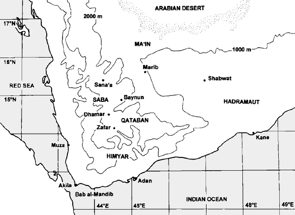
As with prehistoric sites, the dating of the historic period of Yemen is developing rapidly, due to the increased intensity of archaeological work. The periods for which there are textual sources are now divided in: Archaic South- Arabian (1200 - 700 BC), Ancient South-Arabian (700-110 BC), Middle South- Arabian (110 BC - 300 CE), Himyarite period (300 - 525 CE), Axumite rule (525 - 570) and Persian rule (570 - 632) (after Robin 1982, 6 and 1997). In the Baynun area all these periods seem to be present. The rock inscriptions of Shamr probably attest the Archaic South-Arabian phase, although detailed epigraphical work is necessary to confirm this. The Ancient South-Arabian phase is the summit of the powerful kingdoms of Saba and Qataban, linked to the incense trade. The famous trade cities of Yemen were all located at the Eastern edge of the highlands, where the caravan routes for the incense trade passed through the desert while water was available from the hinterland wadis. The complicated history of the changing supremacy of each of the several powerful kingdoms during the Middle South-Arabian period, is reflected in the incongruous accounts of South-Arabian leadership as described in the Periplus of the Erythraean Sea, and ancient authors such as Ptolemy, Strabo and Pliny. The most conspicuous remains in the Baynun area are the ruins of the town of Baynun itself, dated to the Himyarite period, when it was one of the capitals of the empire.
The town of Baynun was famous for its beauty. A manuscript
by the eleventh century CE author al-Hasan Ahmad al-Hamdani on the public
buildings of Yemen cites several texts dealing with Baynun and the mythical
history that it has been built by demons. Hamdani also describes two tunnels,
which are still to be found today, but refers to them as ‘carved roads'.
"Baynun is in the eastern part of the land of Ans, faced on the opposite side
by Kura of Kawman. It is a great settlement, full of wonders. (...) In [Baynun]
are two great roads which are carved through two mountains and are therefore
difficult to find. Consequently, they are not frequented by the caravans".
In 1970 the Baynun area was visited by Radt and Müller, who both wrote
brief reports on the tunnels and the inscriptions. One of the tunnels has
collapsed, but the other is still an impressive feature in the landscape.
The remains of channels, and the sand deposits on the floor of the tunnel,
clearly indicate that the objective for this miracle of engineering was the
transfer of water into the Wadi Shumuly. Apparently the tunnels did not only
function as such, since Hamdani describes them as ‘roads' and seems to be
mildly surprised that these roads are hidden. Important comparative material
for our work were the surveys and excavations done by an American expedition
directed by M. Gibson and T.J. Wilkinson on the Dhamar plain.
|
|
|
|
|
|
|
|
|
|
|
|
|
|
|
|
|
|
|
|
|
|
|
|
|
|
|
|
|
|
|
|
|
|
|
|
|
|||||||||||||