|
|
|
|
|
|
|
|
 |
|
 |
|
|
|
|
|
|
|
|
|
|
|
To draw a measured plan of the site and study the surface remains (including the ceramic finds). |
|
|
- January
1998 - August 1998 |
|
|
|
Prof.Dr. Steve Sidebotham (University of Delaware), Eng. Wolf Schijns and Barbara Tratsaert (Berenike Project). | |
| Results: | A survey was performed using the Global Positioning System, a theodolite and steel tape measures. Off-site assistance was given by pottery expert Dr. Roberta Tomber (Museum of London). No excavations took place. A full publication of this site is pending. | |
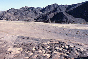
| Approximate position and date of the site: | Umm Howeitat Qibli is in the southern part of the Egyptian Eastern desert, halfway between the Quft-Quseir and Edfu-Marsa Alam asphalt roads and close to the Red Sea coast. Surface pottery dated to the Ptolemaic period (ca. 330 - 30 BC). | |
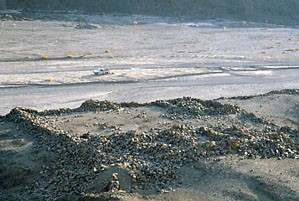
| Short description of the site: | Umm Howeitat Qibli was a gold mine which was operational in Ptolemaic times and during the first half of the 20th century. The surface is littered with ancient pot sherds, grinding stones and quartz pounders. In the surrounding hills many places can be seen where quartz veins were excavated to extract the gold. | |
| Additional remarks: | At this site the whole ancient gold mining process can be seen in situ as it has not (yet) been seriously disturbed. The modern mine is somewhat inland from the ancient one and a concrete well in the middle of the ancient settlement is the only trace of it. Our work was sponsored by the Berenike Project, the University of Delaware and private donors. | |
| HOME |
|
|