|
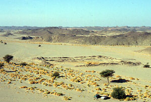
An overview of the hydreuma, of
which the
north-eastern corner has been damaged by a flood that once went through
the wadi:
|
|
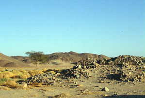
Where intact, the walls of the hydreuma
(with
faces of large stones and a core of rubble) still stand to a
considerable
height:
|
|
|
|
|
|
|
|
|
|
|
|
|
|
|
|
Objective of visit:
|
|
To draw a measured plan of the site and study
the surface
remains (including the ceramic finds). |
|
Date of visit:
|
|
January
1994 |
|
Fellow visitors:
|
|
Eng. Ron Zitterkopf and Hagg Tawfiq (our
bedouin guide). |
| Results: |
|
A survey was performed using steel tape
measures. Off-site
assistance was given by pottery expert Dr. Roberta Tomber (Museum of
London).
No excavations took place. A full publication of this site is pending. |
| Approximate
position and date
of the site: |
|
Samut is in the southern part of the Egyptian
Eastern
desert, south of the Edfu-Marsa Alam asphalt road. Surface pottery
dated
to the Roman period (ca. 30 - 600 AD) but the find of a grinding
stone, as well as the historic sources, indicate a much earlier date. |
| Short description
of the site: |
|
Samut was a stop on the ancient road from the
harbour
at Berenike to the Nile. Here caravans could find water, food and
shelter
for the night. The find of a grinding stone, of the type as used in
ancient
gold mines, confirmed the idea that the hydreuma must also have
accommodated the nearby Ptolemaic gold mines. |
| Additional
remarks: |
|
About 10 km. north of the hydreuma,
the remains
of an large gold mine were discovered. These appeared to be Ptolemaic
in
date. Our work was sponsored by the Berenike Project and private donors. |
| HOME |
|
|
 |
|
|