|
|
|
|
|
|
|
|
 |
|
 |
|
|
|
|
|
|
|
|
|
|
|
To draw a measured plan of the site and study the surface remains (including the ceramic finds). |
|
|
- July 1997
- August 1998 - June 1999 |
|
|
|
Prof.Dr. Steve Sidebotham (University of Delaware), Prof.Dr. Jim Harrell (University of Toledo), Dr. Abdel-Maqsoud (EGSMA) and Saleh Ali (our Bedouin guide). | |
| Results: | A survey was performed using the Global Positioning System and a theodolite with steel tape measures. Off-site assistance was given by pottery expert Dr. Roberta Tomber (Museum of London). Our work was published in the Journal of Egyptian Archaeology 2001; 87: 135-170. | |
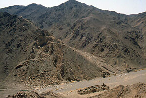
| Approximate position and date of the site: | Wadi Umm Wikala is a tributary of Wadi Semna in the central part of the Egyptian Eastern desert, between the Qena-Safaga and Quft-Quseir asphalt roads. Surface pottery dated to the beginning of the Roman period (ca. 30 BC- 300 AD). | |
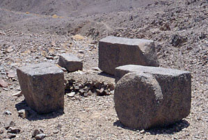
| Short description of the site: | The stone working areas and related settlement in Wadi Umm Wikala are closely associated with the hydreuma in Wadi Semna. Stone was quarried here in Roman times and subsequently roughly shaped, transported to the Nile valley and from there to Alexandria and Rome. | |
| Additional remarks: | Early travellers have described the quarry in Wadi Umm Wikala and found several inscriptions here. Our work was sponsored by the University of Delaware, the University of Toledo and private donors. | |
| HOME |
|
|